
View Current Newsletter -
Search The Archive
Sign Up - Print
Issue
266
Article
419
Published:
10/1/2020
Chris Burti, Vice President and Senior Legal Counsel
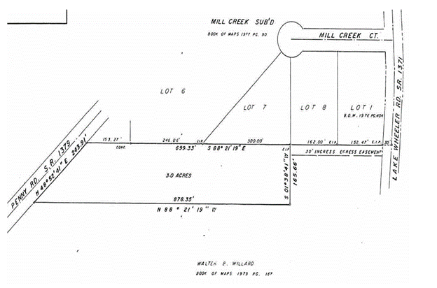
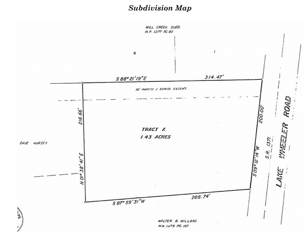
This appeal was from a trial court judgment on the pleadings where a thirty-foot wide easement was depicted on plats in the parties' respective chains of title that were referenced in the original deeds from the common owner. A significant part of the opinion discusses procedural issues raised in the appeal which we will not discuss further. The two plats used to convey the property in the respective chains of title used by the common grantor and referenced in the original deeds were included in the opinion and shown below.
The first plat shows the three acre parcel first conveyed by reference to the plat and depicts a "30' INGRESS EGRESS EASEMENT"
The second plat shows the 1.43 acre tract of the defendants and it also depicts the easement.
The defendants contended that there was a question of facts because:
1. there was no express grant or reservation of the easement in either chain of title,
2. the purported easement was depicted by a dotted line and not surveyed,
3. the description was ambiguous because the designation of 30' wasn't clear as to whether it referred to distance or width.
Citing Tanglewood Prop. Owners' Ass'n, Inc. v. Isenhour, 254 N.C. App. 823, 830, 803 S.E.2d 453, 458 (2017) the opinion, (ellipsis and citation omitted), relates that when an appurtenant easement is created for the purpose of benefiting particular land, it attaches to, passes with, and is an incident of ownership of that land. It may be created in several ways, including grant, estoppel, way of necessity, implication, dedication, prescription, reservation, and condemnation.
Though easements generally must be created in writing, courts will find the existence of an easement implied by plat as the doctrine is recognized in North Carolina. An appurtenant easement may be created by implied dedication formally or informally and may be created when the purchaser is conveyed the land by a description that relies on a plat where the land is sold in reference to it, the plat depicts the easement with sufficient information to adequately describe it and court expresses the doctrine that an express grant is not required.
As to the adequacy of the description of the easement depicted by these plats:
"Both recorded maps show that easement across Defendants' property: (a) is labeled as an ingress/egress easement; (b) is coterminous with the northern boundary of Defendants' property, which is described in metes and bounds in the Barbour Jr. Deed, on the Subdivision Map, and on the Penny Rd. Property Map, and is labeled 314.47 feet long; (c) intersects with Lake Wheeler Road on its east side; (d) intersects with the Penny Rd. Property on the west side; and (e) is 30 feet wide, as can be inferred from the "30' ingress/egress easement" label."
The defendants further argued that it is not possible to determine if the easement is 30 feet wide since the easement's label on the Subdivision Map does not contain the word "wide" and that the southern boundary line of the easement is not capable of being located "because it is represented by a dotted line, which indicates that this boundary was not surveyed." The court summarily disposed of the issues by stating:
"...according to the Subdivision Map, the length of the easement is 314.47 feet. Hence, the 30-foot descriptor refers to the width of the easement...The northern boundary of the easement is coterminous with the northern boundary of the Lake Wheeler Rd. Property. The southern boundary of the easement is located 30 feet from and below the northern boundary of the property at all points along the easement."
This opinion is useful to title examiners because it makes it clear that in North Carolina the doctrine is well established that when a plat depicts an easement benefitting property over the grantor's remaining, the plat is then used to convey that property and using all reasonable inferences from the information on that plat, it adequately describes the easement, the use creates an appurtenant easement for the grantee. As it is in the chain of title of any successor in interest of the grantor, it burdens that successors land even where, as here, the map is not used in the successor's grant. See Reed v. Elmore, 246 N.C. 221 (1957).
- Home
- ALTA Best Practices
- TRID
- Register of Deeds
- Calculator
- Forms
- Priors
- Commercial
- Newsletters
- What Is Title Insurance?
- News
- Your ?'s
- About Us
- Contact Us
- History
- Rates
- Ratings
- Our Creed
- En Español
- Privacy
Resources

Statewide Title, Inc. is a member of ALTA®, the NCLTA and the FEA.